
When Water Meets Heritage: Understanding Flood Risk in Historic Dutch Cities
A deep dive into how advanced geospatial analysis reveals vulnerability patterns in Deventer’s medieval cityscape
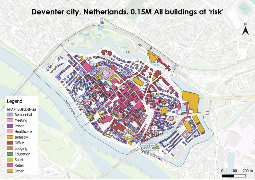
The Netherlands has always lived in delicate balance with water. Nowhere is this relationship more complex than in historic cities like Deventer, where centuries-old architecture meets modern flood management challenges. Recent flood risk modeling reveals a sobering reality: at 0.15 m depth flood in this charming Hanseatic city face significant flood exposure.
The Anatomy of Urban Flood Risk
Our latest geospatial analysis of Deventer paints a detailed picture of vulnerability across different building types and neighborhoods. The color-coded visualization above demonstrates how flood risk doesn’t discriminate – it affects residential homes, critical healthcare facilities, educational institutions, and commercial districts alike.
Key Findings from the Analysis
Critical Infrastructure at Risk: The mapping reveals that essential services including healthcare facilities (shown in pink) and educational buildings (in green) are distributed throughout flood-prone areas. This presents significant challenges for emergency response and community resilience planning.
Mixed-Use Vulnerability: Deventer’s historic city center showcases the complex interplay between residential areas (purple), commercial districts (dark red offices, light green retail), and industrial zones (yellow). This mixed-use pattern, while culturally rich, creates cascading risk scenarios where flood impacts can ripple across multiple sectors simultaneously.
Historic Preservation Meets Modern Challenges: The dense concentration of buildings within the historic city boundaries – clearly delineated by the medieval city walls – represents both cultural treasure and flood management complexity.
The Data Behind the Story
Advanced flood modeling combines multiple data layers:
- Topographic elevation models revealing low-lying areas
- Hydrological flow patterns from nearby rivers and waterways
- Building footprint analysis categorizing structures by type and use
- Demographic data identifying vulnerable populations
This multi-layered approach enables planners to move beyond simple flood zone mapping toward nuanced risk assessment that considers both physical exposure and community vulnerability.
Implications for Water Management Strategy
1. Targeted Intervention Priorities
The granular building-level analysis allows municipalities to prioritize flood protection investments. Healthcare facilities and schools require immediate attention, while residential areas need community-based resilience planning.
2. Heritage-Sensitive Solutions
Traditional flood defenses may not be appropriate for historic districts. The analysis supports development of nature-based solutions and adaptive strategies that preserve cultural character while enhancing protection.
3. Emergency Preparedness
Understanding which building types are most exposed enables more effective evacuation planning and resource pre-positioning. The concentration of vulnerable facilities in certain areas suggests opportunities for consolidated emergency response centers.
The Future of Flood Risk Intelligence
This Deventer analysis represents the cutting edge of flood risk assessment – moving from broad hazard zones to building-specific vulnerability profiles. As climate change intensifies extreme weather patterns, this granular understanding becomes essential for:
- Insurance and financial planning
- Real estate development decisions
- Infrastructure investment prioritization
- Community resilience building
Why This Matters Now
With sea levels rising and extreme precipitation events becoming more frequent, cities like Deventer cannot afford reactive approaches to flood management. Proactive, data-driven strategies – informed by comprehensive geospatial analysis – offer the best path forward for protecting both people and places.
The 150,000 buildings identified in this analysis aren’t just structures – they’re homes, workplaces, schools, and community gathering spaces. Each represents lives and livelihoods that depend on informed decision-making about water risk.
Ready to understand flood risk in your community? Quotient Water Data combines advanced modeling, comprehensive datasets, and actionable insights to help municipalities, businesses, and organizations make informed decisions about water-related risks. Contact us to learn how geospatial intelligence can strengthen your resilience planning. Contact Quotient Water Data
About the Analysis: This flood risk assessment utilized high-resolution digital elevation models, building footprint databases, and hydrological modeling to identify structures within designated flood zones. Analysis conducted using industry-standard GIS platforms and validated against historical flood records.